Peaks · California
San Gorgonio Mountain, Southern California's highest peak
Old Greyback, the bare rocky top of Southern California, rising above treeline. Here's the climb, the permit, what's on top and how to get the summit photo.
San Gorgonio Mountain at a glance
- Summit elevation
- 11,503 feet, the figure in the Forest Service trail guide and San Bernardino County's history of the mountain. Other Forest Service pages list 11,499 or 11,502 feet.1,2,3,4
- Standing
- The highest peak in Southern California, and the highest in California south of the Sierra Nevada. Its summit rises well above treeline, which earned it the nickname Old Greyback.1,3,4
- Where
- San Gorgonio Wilderness, San Bernardino National Forest, co-managed by the Forest Service and the Bureau of Land Management1
- Vivian Creek Trail
- The shortest and steepest route. About 7.8 miles one way to the summit, adding up the Forest Service's segment mileages, from a trailhead near Forest Falls at about 6,000 feet, so you climb more than 5,000 feet. Rated difficult and strenuous.2,3
- Other routes
- The South Fork Trail (trailhead at 6,900 feet) and the Fish Creek Trail (trailhead at 8,180 feet) both reach Mineshaft Saddle, then follow the Sky High Trail for the last 3.5 miles to the top.3
- Permits
- Free wilderness permits are required for day hikes and overnight trips. They're issued online only, through the San Gorgonio Wilderness Association, up to 90 days ahead, for groups of up to 12. You also need an Adventure Pass or another accepted recreation pass to park.1,2,5
- Weather
- Snow and ice make the steep terrain dangerous in winter, spring and early summer. The Forest Service says those seasons call for mountaineering experience, traction devices and an ice axe you know how to use. Wind can pick up sharply at the peak, so bring warm layers.1,2,3
The summit sign
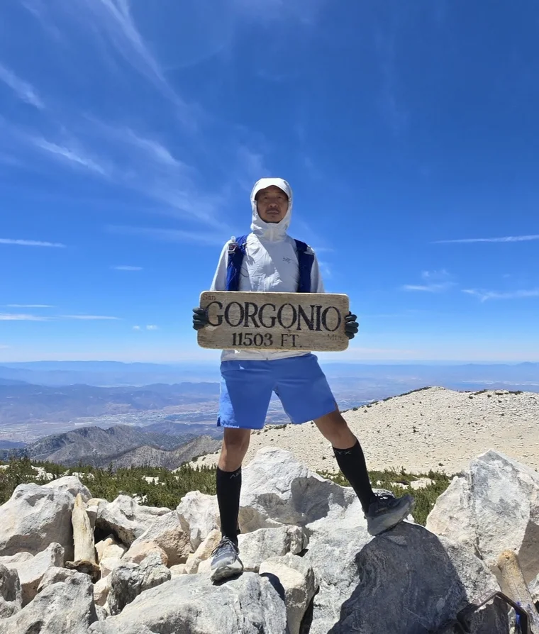
In our Real Summit photo the hiker is holding a weathered wooden sign, carved GORGONIO, 11503 FT., with San and Mtn in smaller letters, on the broad, rocky top with the desert and ridges far below. The Forest Service pages don't describe a summit sign, so whether you find one up there or carry your own, your charm keeps it in, readable, right beside you.
Getting the summit photo
- If there's a sign on top when you get there, hold it in front of you at chest height. If not, bring your own with the name and height in thick dark marker.
- Stand clear of the windbreaks so the open rocky top and the long views are behind you.
- Get your whole body in, head to boots, and hold the sign tight. The wind at the top can be strong.
San Gorgonio Mountain questions
How tall is San Gorgonio Mountain?
The Forest Service trail guide and San Bernardino County list 11,503 feet. Other Forest Service pages give 11,499 or 11,502. Any way you count it, it's the highest peak in Southern California.
Do you need a permit to hike San Gorgonio?
Yes. Free wilderness permits are required for day hikes and overnight trips, and they're issued online only through the San Gorgonio Wilderness Association, up to 90 days ahead.
What's the shortest trail up San Gorgonio?
The Vivian Creek Trail, which the Forest Service calls the shortest and steepest route. It's about 7.8 miles one way to the summit, climbing more than 5,000 feet.
Is there a summit sign on San Gorgonio?
The Forest Service pages don't describe one. In our Real Summit photo the hiker holds a weathered wooden sign reading San Gorgonio Mtn, 11503 ft. Whatever sign you hold up, we keep it in your charm.
Carry your San Gorgonio Mountain summit
All those training miles, for the top of Southern California. We cut your summit photo to your outline with your sign kept in, so you carry Old Greyback on every hike after... proof you stood there.
One email when charms are ready to order. Unsubscribe anytime.
Launching soon · $29 with free US shipping · Made right, or made again
Proud of someone who just made the top? Use the photo they sent you and give them their summit to carry. How gifting works
Sources
- USDA Forest Service, San Bernardino National Forest, San Gorgonio Wilderness.
- USDA Forest Service, San Bernardino National Forest, Vivian Creek Trail 1E08.
- USDA Forest Service, San Bernardino National Forest, San Gorgonio Wilderness trails guide (PDF).
- San Bernardino County, San Bernardino County history: Mount San Gorgonio.
- San Gorgonio Wilderness Association, Wilderness permits.
Trail, snow and road conditions change. Check with the San Bernardino National Forest before you go. Facts checked October 2026.