Peaks · Washington
Mount St. Helens, 8,365 feet
The volcano that lost about 1,300 feet in 1980, with a climb that ends on the rim looking into the crater. Here's the route, the permit and how to stay safe at the edge.
Mount St. Helens at a glance
- Summit elevation
- 8,365 feet (2,550 meters), the highest point of the crater rim, on the southwest side1,3,4
- Standing
- Before the May 18, 1980 eruption the summit stood at 9,677 feet. The eruption removed about 1,300 feet of the cone.4
- Where
- Mount St. Helens National Volcanic Monument, Gifford Pinchot National Forest, managed by the USDA Forest Service1
- Monitor Ridge
- The main summer route. About 5 miles and 4,500 feet of gain to the crater rim from Climbers Bivouac at 3,700 feet. Most climbers take 7 to 12 hours round trip. Wooden posts mark the way to about 7,000 feet, and the upper 1,300 feet is unmarked.1,2
- Winter route
- The Worm Flows route, from Marble Mountain Sno-Park1
- Climbing permit
- Required year round for anyone above 4,800 feet. From April 1 to October 31 you buy it on Recreation.gov for $20 per climber per day plus a $6 reservation fee, with daily limits of 350 climbers until May 14 and 110 after. Permits go on sale the first day of the month before, at 7 AM Pacific. The rest of the year they're free and you fill one out at the trailhead. One Forest Service page runs the paid season through November 30, so check before you go.1,2,3
- Safety
- The Forest Service calls it a strenuous but non-technical climb for people comfortable scrambling on steep, rugged ground. Stay at least 30 feet back from the edge of the snow cornice on the rim, and never enter the crater, which is prohibited. Volcanic hazards can't be forecast.1,2,3
The crater rim
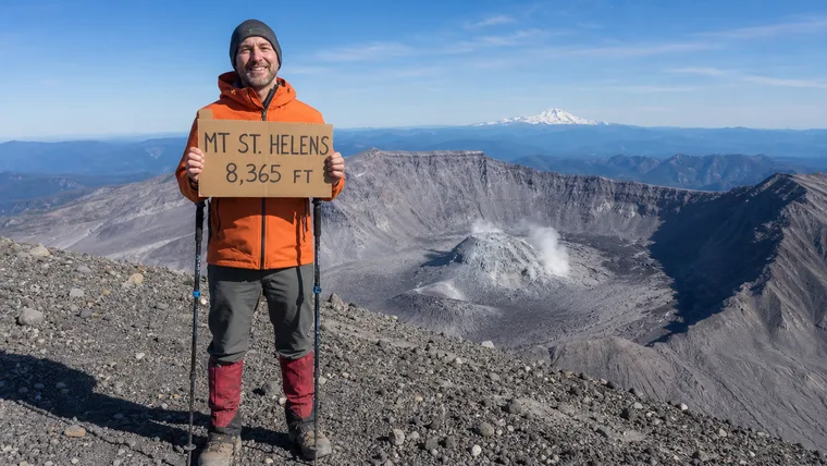
The top is the crater rim, with the 1980 crater below you and neighboring Cascade peaks around you. The Forest Service and Recreation.gov pages don't describe a summit sign, and in winter and spring a snow cornice can hang far out past the edge. If you want the name and height in your shot, carry up your own sign, and your charm keeps it in.
Getting the photo
- Take it well back from the rim. The Forest Service says to stay at least 30 feet from the visible edge of the cornice.
- Frame yourself so the crater and the peaks beyond are behind you, and get your whole body in, head to boots.
- Bring your own sign, written large in thick dark marker, and hold it at chest height so it doesn't cover your face.
Mount St. Helens questions
Do you need a permit to climb Mount St. Helens?
Yes, year round, for anyone going above 4,800 feet. From April 1 to October 31 you buy it on Recreation.gov for $20 per climber per day plus a $6 reservation fee. The rest of the year it's free and you fill it out at the trailhead.
How long is the Mount St. Helens climb?
The Monitor Ridge route is about 5 miles one way with 4,500 feet of gain to the crater rim. Most climbers take 7 to 12 hours round trip.
How high is Mount St. Helens?
The highest point of the crater rim is 8,365 feet. Before the 1980 eruption the summit stood at 9,677 feet.
Can I go into the crater?
No. Entering the crater is prohibited. Stay on the rim, and stay at least 30 feet back from any snow cornice.
Carry your crater rim climb
Five miles of pumice and ash to stand on the rim of a volcano. We cut that photo to your outline with your sign kept in, so the crater rim comes with you on every hike after.
One email when charms are ready to order. Unsubscribe anytime.
Launching soon · $29 with free US shipping · Made right, or made again
Proud of someone who just made the top? Use the photo they sent you and give them their summit to carry. How gifting works
Sources
- USDA Forest Service, Gifford Pinchot National Forest, Mount St. Helens Summit.
- USDA Forest Service, Gifford Pinchot National Forest, Monitor Ridge Climbing Route.
- Recreation.gov, Mount St. Helens Climbing Permit.
- US Geological Survey, How high was Mount St. Helens before and after the May 18, 1980 eruption?.
Permit dates, snow and volcanic conditions change. Check with the Mount St. Helens National Volcanic Monument before you go. Facts checked October 2026.