Peaks · California
Mount Shasta, 14,179 feet
A glaciated volcano and a true mountaineering climb, with ice axe, crampons and helmet. Here's the route, the passes, what's on top and how to get the summit photo.
Mount Shasta at a glance
- Summit elevation
- 14,179 feet, the Forest Service figure. The same Forest Service page also lists 14,162, and USGS satellite mapping gives 14,163 feet (4,317 meters).1,3,4,5
- Standing
- The most voluminous of all the Cascade Range volcanoes. Hot springs and volcanic gases still seep from the summit.3
- Where
- Mt. Shasta Wilderness, Shasta-Trinity National Forest, with climbing information from the Mt. Shasta Ranger Station1
- Avalanche Gulch
- The most popular route and the one the Forest Service calls the easiest. Five to six miles from Bunny Flat to the summit with over 7,000 feet of gain, and at least 8 to 12 hours round trip. Conditions are usually best from mid-May to mid-July.1,2
- Summit Pass
- Required above 10,000 feet. $25 per person, good for up to 3 days, or $30 for an annual pass through December 31. Climbers under 16 don't need one.1,2
- Wilderness permit
- Also required year round to enter the wilderness. Free, with no quota, from the Mt. Shasta and McCloud Ranger Stations and open trailheads. Human waste must be packed out anywhere in the wilderness, and pack-out bags are free.1,2
- Mountaineering
- The Forest Service says crampons, an ice axe and a helmet are a necessity on Avalanche Gulch and most other routes. Glaciers have crevasses, rockfall picks up on the south slopes after midsummer, major storms can bring high wind and snow any time of year, and lightning storms are common in summer.1,2
The summit register
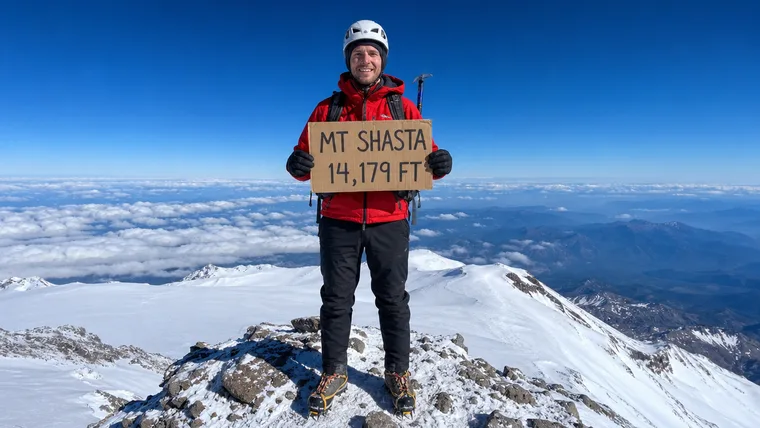
Forest Service climbing rangers maintain a summit register at the top and archive it at the Bancroft Library at UC Berkeley, so signing in puts your climb in the record. The agency pages don't describe a summit sign. If you want the name and height in your shot, carry up your own sign, and your charm keeps it right in your hands.
Getting the photo
- Bring your own sign and write the name and height large, in thick dark marker. Gloves make small writing hard to hold steady.
- Get your whole body in, head to boots, crampons and axe included.
- Take it fast and keep moving. Weather on Shasta can turn quickly, and temperatures can drop sharply even in late summer.
Mount Shasta questions
Do you need a permit to climb Mount Shasta?
Yes, two things. A free wilderness permit, required year round to enter the wilderness, and a Summit Pass to go above 10,000 feet, $25 per person for up to 3 days or $30 for the year. Climbers under 16 don't need the Summit Pass.
Do you need mountaineering gear to climb Mount Shasta?
Yes. The Forest Service says crampons, an ice axe and a helmet are a necessity on Avalanche Gulch and most other routes, and the county sheriff says to get training with crampons before climbing snowfields and never to climb alone.
How tall is Mount Shasta?
The Forest Service lists 14,179 feet. The same page also gives 14,162, and USGS satellite mapping gives 14,163 feet.
Is there a summit register on Mount Shasta?
Yes. Forest Service climbing rangers maintain a summit register and archive it at the Bancroft Library at UC Berkeley.
Carry your Mount Shasta climb
Months of prep, an ice axe, crampons and over 7,000 feet of snow and volcano to stand on top. We cut that photo to your outline with your sign kept in, so you can carry Shasta on every hike after.
One email when charms are ready to order. Unsubscribe anytime.
Launching soon · $29 with free US shipping · Made right, or made again
Proud of someone who just made the top? Use the photo they sent you and give them their summit to carry. How gifting works
Sources
- USDA Forest Service, Shasta-Trinity National Forest, Mt. Shasta Wilderness.
- USDA Forest Service, Shasta-Trinity National Forest, So you want to climb Mt. Shasta (handout).
- US Geological Survey, Mount Shasta.
- US Geological Survey, California Volcano Observatory, How tall are you really? Establishing Mount Shasta's summit elevation.
- USDA Forest Service, Mount Shasta climbing rangers, 2025 climbing ranger report (PDF, via Mount Shasta Avalanche Center).
- Siskiyou County Sheriff, Mountain climbers.
Snow, avalanche and route conditions change fast. Check with the Mt. Shasta Ranger Station and the Mount Shasta Avalanche Center before you go. Facts checked October 2026.