
Your Humphreys Peak summit
Your Humphreys Peak summit
You stood on Humphreys Peak. Carry that day.
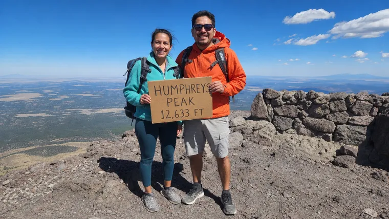
Turn your Humphreys Peak summit photo into an acrylic pack charm, cut to your outline with the sign or plaque kept in. $19 with free US standard shipping. Review your preview before you order.
Your Humphreys Peak charm, at a glance.
- Your photo
- Made from your own Humphreys Peak summit photo.
- Shape
- Your outline, with the summit sign or plaque kept in.
- Material and size
- Two-layer print sealed inside clear acrylic, with a clear acrylic edge. About 3 inches.
- Attachment
- Lobster clasp.
- Price
- $19, with free US standard shipping.
- Delivery
- Allow 6 to 17 business days from order to delivery.
Keep the sign in the moment.
The summit sign or plaque is part of your Humphreys Peak photo. Your charm keeps it with your outline. Review the preview to check your face, the marker and the details you want to carry.
Choose your photo from the top.
- Show your full body, from head to boots.
- Keep the summit sign or plaque close to you and clearly visible.
- Use a sharp original photo when you have it, then check your preview.
Making your Humphreys Peak charm.
Do I use my own Humphreys Peak photo?
Yes. Upload your own summit photo. The photographs on this page show examples; your charm is made from the photo you provide.
Will the summit sign stay in?
The charm follows your outline with the summit sign or plaque kept in. Choose a photo with the marker close to you and check that it appears as you want in the preview before approving it.
Can I change my order?
Email support@mysummitcharms.com within 12 hours of ordering to request a change to your photo or cutout, or the address, or to cancel. After that, production begins and changes or cancellations aren't available.
Your Humphreys Peak photo. Your next-hike companion.
You know what it took to get there. Make your photo from the top into a charm you can clip to your pack or keys. Check the preview and approve it before you order.
$19 · Free US standard shipping · Made right, or made again
Making one for someone who summited Humphreys Peak? Start with their summit photo. How gifting works
Planning your Humphreys Peak hike?
On the list: State high points.
Humphreys Peak at a glance
- Summit elevation
- 12,633 feet in the Forest Service trail guide. Some Forest Service pages list 12,643 feet.2,3
- Standing
- The highest point in Arizona, on the San Francisco Peaks, a dormant volcano.1,3
- Where
- Kachina Peaks Wilderness, Coconino National Forest, north of Flagstaff. The trail starts at Arizona Snowbowl.2,3
- Humphreys Trail No. 151
- About 5 to 5.5 miles one way, with 3,420 feet of gain. Plan on 3 to 4 hours each way.1
- Thin air
- The trail starts above 9,000 feet. Breathing gets harder as you climb, so expect to stop more often.1
- Above treeline
- It can be much colder and windier than at the trailhead.1
- Stay on the trail
- The alpine tundra is fragile. The Forest Service closes the area off the trail above treeline to camping and off-trail hiking.2,4
- Winter
- After storms there can be avalanche danger on steep slopes near and above treeline.5
Humphreys Peak questions
How tall is Humphreys Peak?
The Forest Service trail guide lists 12,633 feet. It's the highest point in Arizona.
How long is the Humphreys Peak hike?
Humphreys Trail No. 151 is about 5 to 5.5 miles one way with 3,420 feet of gain, roughly 3 to 4 hours each way.
Where does the Humphreys Trail start?
At Arizona Snowbowl, about 7 miles up Snowbowl Road north of Flagstaff.
Can you leave the trail near the top?
No. The alpine tundra above treeline is closed to off-trail hiking and camping to protect it.
Sources
- USDA Forest Service, Coconino National Forest, Humphreys Trail No. 151.
- USDA Forest Service, Coconino National Forest, Hiking the Kachina Peaks Wilderness trails (PDF).
- USDA Forest Service, Coconino National Forest, Kachina Peaks Wilderness.
- USDA Forest Service, Coconino National Forest, San Francisco Peaks alpine tundra and Inner Basin restrictions.
- USDA Forest Service, Coconino National Forest, Trail status.
Use these official sources for current trail information and requirements. Trail status, closures and snow change through the year. Check with the Coconino National Forest before you go. Trail facts last checked November 2026.