Peaks · Colorado
Grays Peak, the top of the Continental Divide
The highest point anywhere on the Continental Divide, off I-70 west of Denver, with Torreys Peak close enough to bag the same day. Here's the trail, the road in, and how to get the summit photo.
Grays Peak at a glance
- Summit elevation
- About 14,270 feet. The Forest Service lists the trail topping out at 14,272 feet, NOAA's preliminary 2024 survey puts the summit near 14,276, and the 1979 National Recreation Trail record says 14,278.1,4,5
- Standing
- The highest point on the Continental Divide3,4
- Where
- Arapaho and Roosevelt National Forests, Clear Creek Ranger District, off I-70 west of Denver1,2
- Grays Peak Trail
- Trail #54, a National Recreation Trail since 1979. About 3.3 miles to the summit with about 3,000 feet of gain. You can add Torreys Peak and summit two fourteeners in one day.1,3,4
- Getting there
- Take I-70 to the Bakerville exit (#221), then about four miles up Stevens Gulch Road (County Road 321). The road is rough, may need four-wheel drive at times, and is impassable in winter, when you may have to start from the parking area off I-70.1,2
- Season
- Because it's so high, the area usually isn't snow free until late June, or even July in some years1,2
- Weather
- Weather changes fast. The Forest Service says to start early in the morning to avoid afternoon lightning storms.1
- Dogs
- Allowed on a hand-held leash1,2
The summit sign
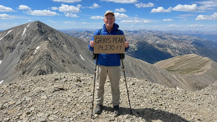
The Forest Service pages we read don't describe a summit sign on Grays. If you bring your own to hold up for the photo, make it big and dark so it reads. And if you top out on Torreys too, a second sign makes a fine second charm.
Getting the summit photo
- Bring your own sign and write the name and height large, in thick dark marker.
- Get Torreys Peak in the background if the angle works, since it's close by.
- Get your whole body in, head to boots, and take it early before the afternoon storms build.
Grays Peak questions
How tall is Grays Peak?
The Forest Service lists the trail topping out at 14,272 feet. NOAA's preliminary 2024 survey puts the summit near 14,276, and older records say 14,278. Either way it's the highest point on the Continental Divide.
Can you hike Grays and Torreys in one day?
Yes. The Forest Service says the Grays Peak Trail lets you summit both Grays and Torreys, two fourteeners, in one day.
Can I drive to the Grays Peak Trailhead?
In summer, yes, up Stevens Gulch Road from the Bakerville exit off I-70. The road is rough and can need four-wheel drive. In winter it's impassable, and early or late in the season you may need to start from the lot off I-70.
When is the best time to hike Grays Peak?
The area usually isn't snow free until late June or July. Start early in the morning to be off the summit before afternoon lightning.
Carry your Grays Peak summit
You stood on the highest point of the Continental Divide. We cut that photo to your outline with your sign kept in, so the top of the Divide becomes a badge you carry on every hike after.
One email when charms are ready to order. Unsubscribe anytime.
Launching soon · $29 with free US shipping · Made right, or made again
Proud of someone who just made the top? Use the photo they sent you and give them their summit to carry. How gifting works
Sources
- USDA Forest Service, Arapaho & Roosevelt National Forests, Grays Peak Trail #54.
- USDA Forest Service, Arapaho & Roosevelt National Forests, Grays Peak Trailhead.
- Colorado Trail Explorer, State of Colorado, Grays Peak.
- National Recreation Trails database, Grays Peak Trail.
- NOAA National Geodetic Survey, preliminary 2024 summit heights for Colorado peaks.
Road and snow conditions change. Check with the Clear Creek Ranger District before you go. Facts checked October 2026.